An unstable beginning of May
At least for all the first half of May the weather on the Mediterranean will continue to have the classic features of the spring season: fast storms and unstable days with the first maritime thunderstorms

At least for all the first half of May the weather on the Mediterranean will continue to have the classic features of the spring season: fast storms and unstable days with the first maritime thunderstorms
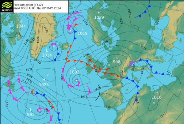
The month of May began in a unstable context, with the passage on the Western Mediterranean of two atantic fronts in rapid sequence. The Anticyclone of the Azores, positioned more in the middle of the Atlantic Ocean, has allowed in the last period the sinking towards the Bay of Biscay of large oceanic lows, which channel perturbed fronts towards Provence, the corridor that leads to the heart of the Mediterranean.
In the attached pressure map we can see the train of the two weather fronts, the first passed on the Peninsula on 1st May already approaching the Balkans, the second active on the Sardinian Sea. The yachts that are trying the first timid crossings along the Peninsula this week had to carefully plan the passages most exposed to western storms, being able to count only on short parentheses of calm during the timid anticyclonic comeback between two disturbed passages.
At least for all the first half of May the weather on the Mediterranean will continue to have the classic features of the spring season: fast storms and unstable days with the first maritime thunderstorms.
At the beginning of the season sailors have a great desire to know what the weather will be like in the summer months, but is it possible? And with what detail? The chaotic character of the atmosphere means that the deterministic prediction in detail can only extend up to 10 days, beyond that time frame we can consult monthly and seasonal probability predictions, which provide a trend on the likely evolution of the state of the atmosphere.
The output of the latter is displayed in terms of deviation of the main weather parameters (pressure, temperature and precipitation) compared to average climatological values, therefore a valid tool to glimpse with great advance extreme events such as intense waves of cold or hot, but not usable for a detailed planning of a summer navigation in the Mediterranean, for example, not containing information such as wind and wave.
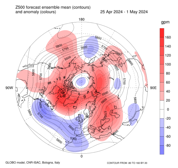
In the second attached map we can see an example of the output of the monthly forecast system of the CNR-ISAC: in the trend issued on March 18 there was a negative anomaly of pressure on Western Europe (blue color) and positive on Eastern Europe (red color) expected in the period 25 April – 1 May which then has actually corresponded to the unstable Atlantic currents that we had in the last week on the Mediterranean.

Pressure anomaly for end of April – Credits CNR-ISAC
Alessandro Casarino – Navimeteo
Topics: Navimeteo


