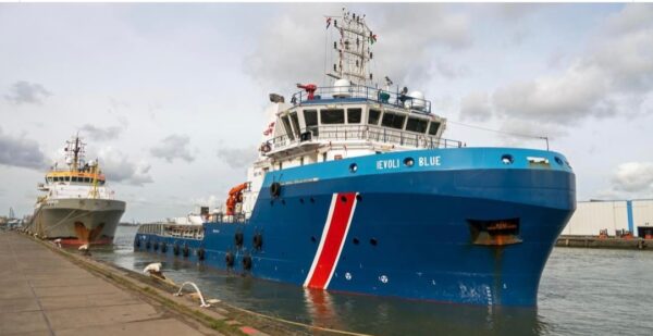
The long route of “Ievoli Blue”
Vuoi salvare articoli per un rapido accesso?
Sali a bordo della community DN Plus.
Per te, un'area riservata con: approfondimenti esclusivi, i tuoi articoli preferiti, contenuti personalizzati e altri vantaggi speciali
Accedi RegistratiThe entire navigation took place in the middle of winter, when the depressions of the North Atlantic are deeper and the risk of Mediterranean storms is more frequent
The entire navigation took place in the middle of winter, when the depressions of the North Atlantic are deeper and the risk of Mediterranean storms is more frequent
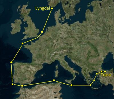
Leaving from Lyngdal in Norway in December, sailing the North Sea, across the English Channel and round Ouessant to the Bay of Biscay and Cape Finisterre, and then head South along the Atlantic coasts of the Iberian Peninsula until the passage of Gibraltar Strait. And then east towards the Channel of Sardinia, the Strait of Sicily, the Ionian Sea, south of the Peloponnese to then heading NorthEast the Aegean up to the Strait of the Dardanelles to enter the Sea of Marmara and finally land in the port of Tuzla in Turkey.
This is the long route followed by Marnavi’s offshore tug and supply vessel Ievoli Blue, with Captain Di Marco Rosario, his crew and operational support from Phoenix Offshore. The entire navigation, carried out without any stops, took place in the middle of winter, when the depressions of the North Atlantic are deeper and the risk of Mediterranean storms is more frequent. Consider that Ievoli Blue towed the Platform Supply Vessel NG Driller of over 70 meters along the entire route, at a speed of around 7Kts.
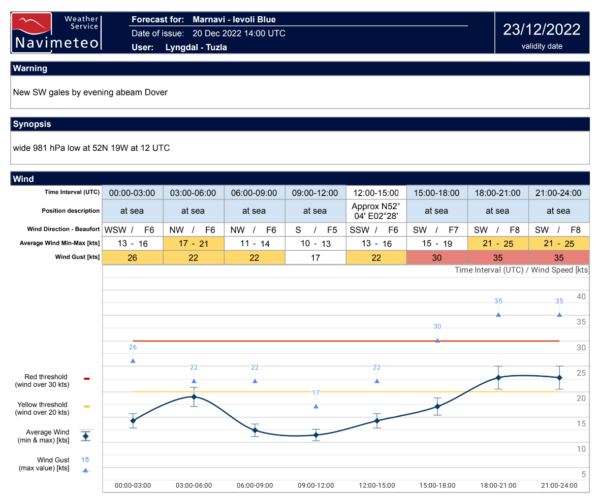
The best time to depart and the constant monitoring of the en route weather conditions represented an important factor for the navigation followed by the convoy. The timely delivered, detailed reports, transmitted every 12 hours by the crew of the Tug Ievoli Blue, have allowed Navimeteo forecasters to compare the real marine weather conditions observed on board with the forecasts and models disseminated by the various centers which form the basis of the analysis of the route.

The support of modern technologies is extraordinarily important, both in the naval and meteorological fields, but the operational dialogue and on-board experience are essential factors, especially in delicate or critical conditions.
Gianfranco Meggiorin