Christmas Trees well anchored for the Gale on the 8th December
On the last 8th December a very strong high pressure was centered in the open ocean, South-West of Ireland, blocking the mild westerly Atlantic flows and favoring a descent of polar arctic air

On the last 8th December a very strong high pressure was centered in the open ocean, South-West of Ireland, blocking the mild westerly Atlantic flows and favoring a descent of polar arctic air
The astronomical autumn continues to proceed with some dynamism over the most of the Mediterranean, unlike in recent years, when the scene in these days was increasingly dominated by a dome of North African high pressure. Following the unsettled jabs that have already occurred since the second half of November, others have in fact happened more recently, and in particular the last one affected our peninsula just on the day of the Immaculate Conception. This is thanks to the so-called “meridian exchanges” that continue to occur over the most of our dear old continent. As the term itself says, they are nothing but exchanges between masses of warm air that rise towards the North and masses of cold air that, on the contrary, descend towards the low latitudes, therefore moving along the meridians of the geographical grid. Instead when a zonal flow dominates, the air masses tend to move essentially along the parallels, thus preventing or at least limiting cold incursions from high latitudes.
More specifically, on the last 8th December a very strong high pressure with maximum of 1045 hPa was centered in the open ocean South-West of Ireland, but with its influence extending from the Azores to Norway, passing through the United Kingdom, consequently blocking once again the mild westerly Atlantic flows and instead favoring as a response a descent of polar arctic air. The strongest contrasts occurred precisely in the border areas between these two powerful baric figures and in particular over the British Isles, where the storm nicknamed Darragh brought gusts of 150-160 km/h, which thanks to a very vast area at its disposal, created truly huge waves over the ocean close to 10m, therefore we are talking about very high seas according to the Dougals scale reported in Table 1. Part of these winds managed to enter into the Mediterranean, creating a minimum downwind to the Alps with values around 994 hPa over the Tyrrhenian Sea off the coast between Tuscany and Lazio, consequently leading to a notable baric gradient over the most of the Central-Western Mediterranean.
| DESCRIPTIVE TERMS | WAVES HEIGHT IN METER |
| 0 Calm | 0 |
| 1 Rippled | 0-0.1 |
| 2 Smooth | 0.1-0.5 |
| 3 Slight | 0.5-1.25 |
| 4 Moderate | 1.25-2.5 |
| 5 Rough | 2.5-4 |
| 6 Very rough | 4-6 |
| 7 High | 6-9 |
| 8 Very high | 9-14 |
| 9 Phenomenal | >14 |
Table 1. Douglas Scale
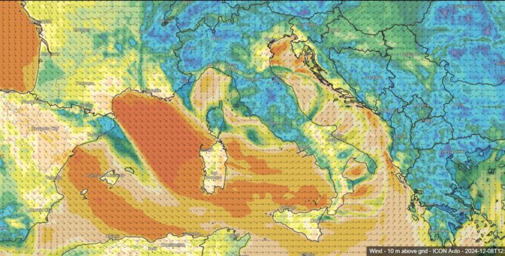
As it can be deduced from Image 1, the impetuous winds entering into the Rhone Valley have violently poured into the Gulf of Lion, where they reached Gale-Storm values according to the Beaufort scale (Table 2), to then gradually propagate towards SE, causing thus Mistral and W’ly Gale on the Sardinian Sea, S’rn Tyrrhenian Sea, Sicily Sea and Channel. Bora up to 100 Km/h over Trieste area, high water in Venice (100-115cm), sustained Tramontana over the Ligurian Sea, with the minimum around which the winds swirl very clearly visible off the Argentario. We would like to point out that the Beaufort scale refers to the average wind speed of 10 minutes duration measured at 10 metres above the ground, not to be confused with the gust, which instead indicates a sort of high-speed wind impulse (according to one definition it must exceed the average wind speed by 10 knots, or 19 km/h).
| GRADE | DESCRIPTION | SPEED KNOTS | SPEED KM/H |
| 0 | Calm | 0-1 | <1 |
| 1 | Light air | 1-3 | 1-5 |
| 2 | Light breeze | 4-6 | 6-11 |
| 3 | Gentle breeze | 7-10 | 12-19 |
| 4 | Moderate breeze | 11-16 | 20-28 |
| 5 | Fresh breeze | 17-21 | 29-38 |
| 6 | Strong breeze | 22-27 | 39-49 |
| 7 | Near gale | 28-33 | 50-61 |
| 8 | Gale | 34-40 | 62-74 |
| 9 | Strong gale | 41-47 | 75-88 |
| 10 | Storm | 48-55 | 89-102 |
| 11 | Violent storm | 56-63 | 103-117 |
| 12 | Hurricane | >63 | >117 |
Table 2. Beaufort Scale
Here are gusts values recorded from North to South by some MeteoNetwork stations located on the coast: 72.4 Km/h Arenzano-Genoa | 81.4 Km/h Comacchio-Ferrara | 77 Km/h Isola di Montecristo-Livorno | 92.2 Km/h Nisida-Naples | 82.3 Km/h Maracalagonis-Cagliari | 91.7 Km/h Palermo | 95 Km/h Barcellona Pozzo di Gotto-Messina.

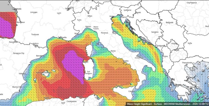
Image 2. Expected significant wave height at 12 UTC on the 8th December 2024 (Credit: MEDWAM Mediterranean model)
In response we obviously had particularly turbulent Italian basins: as it can be deduced from Image 2, the Central-Southern Tyrrhenian Sea was very rough, with seas up to high between the Gulf of Lion, the Balearics, Western Corsica and Sardinia, with waves up to 7m high. Swells of a certain consistency were recorded along the entire Tyrrhenian coast, with the buoy of Gorgona Island-Livorno recording a maximum height of 3m. More precisely, Image 2 reports the expected values of the significant wave height, which is the average height of a third of the highest waves during a particulat time, usually less than 30 minutes.
As for the weather outlook, no significant changes are expected in the medium term: Italy will be a borderland, as often happens during this season, between cold descents from the North, which will more directly head towards Eastern Europe, and attempts to anticyclonic recovery from the West, with a possible contribution from North Africa. However, returning to what was said at the beginning, at the moment the formation of persistent blocking anticyclones seems unlikely, while the polar vortex should continue to be quite disturbed, thus favoring, in alternating phases, the continuation of this atmospheric dynamism.
Antonio Valente – Navimeteo


