First winter maneuvers bring a storm to the Mediterranean
Vuoi salvare articoli per un rapido accesso?
Sali a bordo della community DN Plus.
Per te, un'area riservata con: approfondimenti esclusivi, i tuoi articoli preferiti, contenuti personalizzati e altri vantaggi speciali
Accedi RegistratiAlthough the 'cold' core of the Arctic air mass was not able to fully break into the Mediterranean, the standout feature of this meteorological event was the very strong winds, and consequently, the poor sea conditions
Although the 'cold' core of the Arctic air mass was not able to fully break into the Mediterranean, the standout feature of this meteorological event was the very strong winds, and consequently, the poor sea conditions
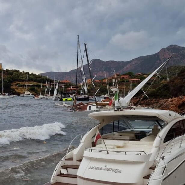
After a first half of autumn that was decidedly mild with late summer characteristics, in the last week we finally had a real taste of winter weather in the Mediterranean. This was due to the first seasonal disturbance of the polar vortex, a low-pressure area that, although permanently located at high latitudes, can sometimes destabilize, causing the intrusion of icy air masses as far as Africa, which greatly influence the course of the Mediterranean winter season.
An oscillation of this cold air dome that envelops the poles occurred just a few days ago, when two strong anticyclones, the Greenlandic and the Azores ones, nearly merged as they moved along the meridians, thereby blocking the milder Atlantic westerly flows and then infiltrating the polar vortex, causing a ‘split‘, i.e., a division of the vortex into two lobes, one of which headed towards the Mediterranean. In the end, although the ‘cold’ core of the Arctic air mass was not able to fully break into the Mediterranean through the Rhône Valley, the standout feature of this meteorological event was the very strong winds, and consequently, the poor sea conditions over the Italian basins.
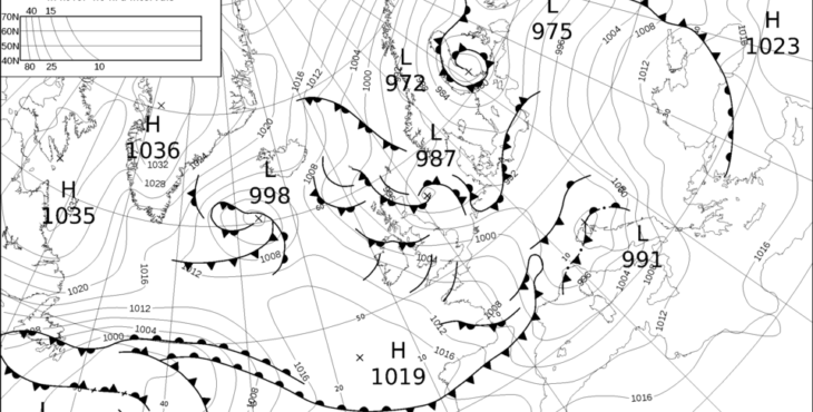
Immagine carta sinottica del 22 nov 2024 (credits UKMO)
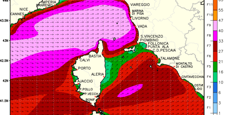
At first glance at the attached synoptic chart, the particularly tight isobars stand out, indicating the significant pressure difference between 999 hPa over the Alpine chain and 1020 hPa over the Iberian Peninsula, a notable pressure difference in a relatively small area, which the winds try to equalize by blowing forcefully.
Noteworthy are the observations of 180 km/h recorded at Cape Corse and 112 km/h reached at Gorgona, which are classifiable as hurricane and storm, respectively, on the Beaufort scale, accompanied by a remarkable increase in wave height on the Ligurian Sea, with a wave height peak of 8 meters recorded by the Gorgona wave buoy early in the morning on November 22. With the subsequent arrival of the extensive cold front, the Mistral wind moved in forcefully over the Gulf of Lion, where it reached violent storm-force levels. In its wake, it left decidedly crisp air and clear skies, as only northern winds can.
Antonio Valente – Navimeteo