The return of anticyclonic conditions over the Mediterranean
Vuoi salvare articoli per un rapido accesso?
Sali a bordo della community DN Plus.
Per te, un'area riservata con: approfondimenti esclusivi, i tuoi articoli preferiti, contenuti personalizzati e altri vantaggi speciali
Accedi RegistratiThe forecasting models show no significant disturbances or instability, suggesting a potential prolonged calm phase
The forecasting models show no significant disturbances or instability, suggesting a potential prolonged calm phase
At the beginning of August, we experienced strong winds, but marine conditions have now greatly improved. A notable rise in barometric pressure coupled with calmer winds has brought tranquility to our waters, benefiting both sailors and recreational boaters along the coast and out at sea.
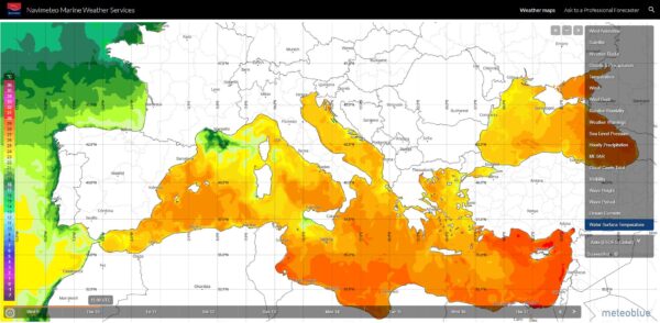
A stable high-pressure system dominates the Western Mediterranean with barometric values between 1020 and 1024 hPa. The pressure gradient, which affects wind force, currently remains weak.
The forecasting models show no significant disturbances or instability, suggesting a potential prolonged calm phase. Thus, current forecasts do not signal any warning for both coasts of the Italian peninsula.

Florian Van Schreven – Calm over the Sea
Interestingly, the prevailing winds have now shifted to coastal breezes. These breezes, coming in from the sea during the day and reversing in the evening-night, are indicative of good weather. However, these breezes with an increased humidity can produce reduced visibility at sea.
It should be emphasized that the Mediterranean climate, especially in its western part, is sometimes complex. Unlike the Atlantic disturbances, systems here are often less pronounced but can sometimes come with unexpectedly strong winds. With decreasing winds, rising sea temperatures and increased evaporation could lead to a more unstable atmosphere and a greater risk of thunderstorms in the medium term, but only starting next week.
Over the years, the Mediterranean has been defined as a region sensitive to climate change. While the current scenario might seem perfect for sea enthusiasts, it’s important to stay updated on weather forecasts and understand the intricacies of the Mediterranean climate to ensure safe and pleasant voyages.
Alberto Cantone – Navimeteo