The weather is like a wave
Vuoi salvare articoli per un rapido accesso?
Sali a bordo della community DN Plus.
Per te, un'area riservata con: approfondimenti esclusivi, i tuoi articoli preferiti, contenuti personalizzati e altri vantaggi speciali
Accedi RegistratiAt our latitudes the change of the weather is given by the wedging of low pressure areas between contiguous high pressure ridges, with vast exchanges of air masses comparable to the passage of a wave
At our latitudes the change of the weather is given by the wedging of low pressure areas between contiguous high pressure ridges, with vast exchanges of air masses comparable to the passage of a wave
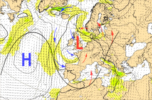
In these days the synoptic picture has shown a Mediterranean frequently divided between a robust high pressure ridge, centered on the Black Sea, and a broad low pressure abeam the Bay of Biscay, while the Azores High stays apart in the middle of the ocean.
The pull of North African winds brings over average and stable hot days on the Levant Sea, Malta, Sicily and the southern basins of the Peninsula, while a wide unstable belt insists on the Western Mediterranean, meeting point between the warm and humid southern winds and the colder Atlantic airflows.
The retrocession or the advance of the two systems, even if only of few hundred Km, determines the fast change of the weather-marine conditions on the various marine basins, typical of the spring time. At our latitudes the change of the weather is given by the wedging of low pressure areas, troughs, between contiguous high pressure ridges, with vast exchanges of air masses between central Europe and sub-tropical Africa, comparable to the passage of a wave.
The atmosphere is a unique mass and the circulation of air is seamless, so the winds at sea level that converge counterclockwise around a depression will be the same as those coming out of the adjacent high pressure areas. This explains the division of time on the Mediterranean of these days: the trough centered on Biscay, stretches towards the Mediterranean, with the pull of the warm Scirocco wind in the frontal side of the wave and with the Maestrale in the back side.
Perturbed lunges usually have a greater amplitude in the winter season while in the spring the Atlantic fronts tend progressively to rise of latitude, passing more frequently north of the Alps, since in June the frequency and length of stable anticyclonic time periods tends to increase.
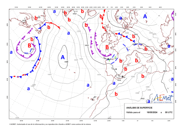
Analisys 16th May – Credits AEMet
Alessandro Casarino – Navimeteo
Topics: Navimeteo